How it works
OpenMapKit (OMK) is an extension of OpenDataKit allowing users to create professional quality mobile data collection surveys for field data collection.
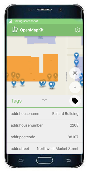
OpenMapKit launches directly from OpenDataKit when the OSM question type is enabled in a standard survey. Simply include OSM questions and tags in your survey to collect information on OSM in the field.
Traditional field data collection tools for OpenStreetMap have either relied on paper or are too complicated, targeted at GIS professionals, or lack an understanding of traditional survey techniques. As new projects such as Missing Maps and other humanitarian field data collection projects focus on field data collection the need for a structured, yet simple, OpenStreetMap field data collection tool became apparent. OpenMapKit serves this need.
Open Street Map Tags
Include standard OpenStreetMap tags in your survey.
Points of Interest
Create new Points of Interest and load those into OpenStreetMap. Simply drop a pin to create a POI and add tags.
Collect Surveys
Securely collect your survey results in OpenMapKit Server. Save your edits and upload your public data to OpenStreetMap.
Open Source
Contribute back to the project. It's Open Source and available on GitHub
